For the most part, clouds are a natural phenomena that occur on celestial bodies that are possessed of an atmosphere, so it will not come as a surprise that clouds occur on earth as well as on some of her sister planets in the solar system such as Venus, Mars, Jupiter and Saturn. Clouds are formed when a body of air is saturated in moisture which floats through the atmosphere above the surface of the planet. Here on earth, water provides the moisture base that permits the formation of clouds. When these particles of moistures congregate together in their billions and trillions, then clouds become visible.
Terrestrial clouds can be classified in a number of ways. One classificatory method is by how the cloud looks to the earthbound observer. Using this system, clouds are cumulus clouds, stratus clouds, cirrus clouds or nimbus clouds; each of which category can be further broken down into sub-categories.
Clouds are also classified by their heights, the measured height being the bottommost part of the cloud rather than the topmost. Using this method of classification, we have high level clouds such as the clouds in the cirrus class which form at a height of six kilometres and more above the surface of the earth; mid level clouds such as altostratus clouds which form at between two to six kilometres above ground level; low level clouds such as stratocumulus clouds which may be expected at heights above the ground of two kilometres and less; and vertical clouds, so called because they rise vertically from their initial formation base and form and reform as they climb ever higher, such as cumulonimbus
clouds which are capable of rising to heights of twelve kilometres and above. Finally, there are some formations such as contrails that do not fit in any of these categories and which may be grouped together as other cloud formations. Because temperatures fall as we move higher up in the earth’s troposphere, the moisturisation of the bodies of air that form the clouds that we see is by water in various forms i.e. water droplets, water vapour or ice crystals, depending on the temperature that subsists at the point where the moisturisation occurs.
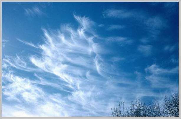
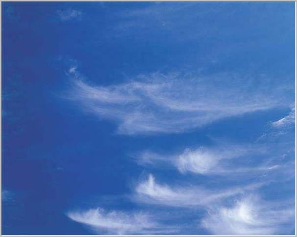
Speaking specifically about cirrus clouds, these formations are an example of high level clouds and they occur in every part of the world. The name cirrus (Latin for hair like) derives from the manner in which the clouds stretch across the sky in delicate hair like strands. At the extreme heights that these clouds form, temperatures are typically below the freezing point for water and the saturation of air bodies at these heights is typically by means of ice crystals Cirrus clouds can be very impressive to view and, depending on the amount of moisture available at the point of formation, these types of clouds can form in solitary patches or they can be spread over considerable expanses of the sky. In patches, such clouds are unlikely to be of any great significance, but where there is an extensive spread across the sky, this may be indicative of a potential weather front. Quite often, cirrus formations are found in association with cumulonimbus clouds. This is as a result of the thunderstorm activity usually associated with cumulonimbus formations. The violence of the storm activity drives up moisture particles further up the troposphere where they become ice crystals and the resulting cirrus cloud can be seen as a wedge shaped formation just above the cumulonimbus formation. Once the storm has abated, winds in the upper tropospheric regions may blow the wedge across the sky and cirrus cloud formations will be seen downwind from the area of storm activity.
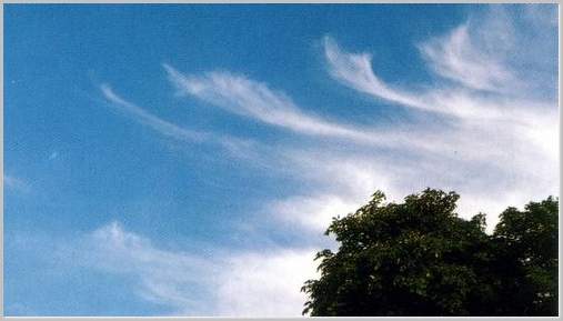
Cirrus clouds come in varied formations, each formation having distinctive characteristics of its own. Cirrus Uncinus or hooked cirrus, uncinus being the Latin for hook, results from the presence of a strong wind just below the saturated air mass which disperses the crystal ice condensed in the air mass and the effect of gravity as the crystals fall earthwards produces the distinct hook shapes. As with other cirrus formations, uncinus may indicate the approach of a weather front or it may signal the presence of a jet stream (a narrow band of high velocity westerlies ten or more kilometres above ground level. Uncinus clouds tend to have a minimal impact on groundside weather, and although snowfall may occur just below the cloud level, such snow is almost always virga, i.e. it evaporated before it reaches the ground.
Cirrostratus clouds are cirrus formations which cover vast areas of the sky. Two types, fibratus and nebulosis are common. Fibratus is indicated by long thin filaments, called striations, spread across a wide expanse of the sky, a result of the ice crystals in the air mass being blown across the sky by a strong and steady high level wind. Nebulosis, on the other hand, is associated with much gentler winds and, as a result, the ice layer may be very thin. This can make the cloud’s presence somewhat difficult to discern; often the only indication of nebulosis’ presence is a slight diminution of the amount of sunlight reaching ground level. There may be some snowfall associated with cirrostratus formations, but such snow is almost always virga.
Cirrus Kelvin-Helmholtz (Cirrus KH) is named for Lord Kelvin, of absolute zero fame, and his German physicist counterpart, Helmholtz, who were the first to describe the conditions that give rise to this type of cirrus formation, which condition also affects liquids and gasses on the surface of earth. Cirrus KH has a distinct corkscrew shape that results from wind shear action i.e. when one layer of air slides across another layer moving at a different speed or in a different direction or both. The results are vertical eddies that produce a regular pattern of air waves. Cirrus KH happens because the eddies produced in this case are considerably stronger than the normal run-of-the mill eddies produced when this situation normally occurs. Such clouds are very uncommon, and, where they occur, they rarely last for more than a couple of minutes or so, for, although KH waves are likely very common in the upper troposphere, there isn’t usually enough moisture at those heights to permit of (long lasting) cloud formations.
One final cirrus formation, contrails, isn’t even a natural phenomenon at all, coming into existence only with the advent of aircraft flying in the higher levels of the troposphere. The exhausts of aircraft engines emit water droplets and, in the upper tropospheric levels, such droplets immediately freeze to form ice crystals thereby creating an artificial cloud. Because there is usually little or no additional moisture at these levels, the clouds formed will be thin and often invisible to earthbound observers. However, if the aircraft happens to be passing through an area where the air mass is sufficiently saturated with moisture the resultant cloud is broader and longer and, lasting much longer, is visible to the earthbound observer. It is this formation that is known as a contrail (condensation trails). Where a contrail is visible to earth side observers, it may be an indication of an approaching weather front.
